


Pest Animal Action Plan for Hume City Council, Victoria: 2012-2015
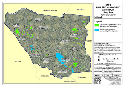 Practical Ecology was commissioned by Hume City Council to prepare a Pest Animal Action Plan for 2012 to 2015. The preparation of this plan was recommended in the Hume City Council Sustainable Land Management Strategy 2010-2013 with the aim of controlling and reducing the impacts of pest animals in the municipality.
Focussing on the European Rabbit and European Red Fox, development of the plan was guided by the preparation of an initial background document that reviewed legislation and policy relevant to pest animal management and the existing Council approach to pest animal control.
This background document also detailed the findings of a complex GIS analysis of the important values across Hume threatened by pest animals, to provide an understanding of where pest animal control may have the greatest biodiversity outcomes.
The resulting Pest Animal Action Plan aimed to provide principles, goals and actions for guiding on-ground pest animal control; increasing awareness and participation by private landowners and the general community; and improving the efficiency and effectiveness of Hume City Council pest animal control works and investment.
Fauna Linkages and Crossing Structure Design for Frankston City Council, Victoria: 2011-2012
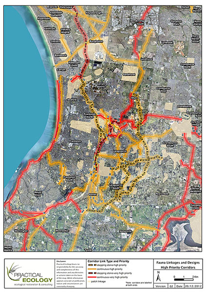 Practical Ecology Pty Ltd was commissioned by Frankston City Council to undertake a detailed in investigation of fauna linkages and wildlife crossing structures within Frankston and adjoining landscape. This study applied a quantitative method to the identification and prioritisation of fauna linkages both at the local and landscape scale to guide future investment and planning decisions by Council. The Southern Brown Bandicoot was selected within the project as a key surrogate species to guide the identification and prioritisation of linkages for fauna and subsequent specifications for habitat creation and maintenance.
The study developed and applied a quantitative approach to the selection and prioritisation in time of locations requiring wildlife crossing structures to facilitate natural movements of fauna between important areas of habitat. In prioritising linkages the study assessed not only the conservation significance of the linkage and connectivity benefit to faunal populations but also the feasibility of implementing each linkages considering numerous factors such as tenure, road barriers, parcel size etc. The project involved extensive liaison with stakeholders, managers, researchers, and community groups/members.
Complex high level GIS analysis was applied to the questions posed by the study using novel approaches developed by our company. The project further built on many years of past experience including a series of projects involving the conservation of threatened species and provision of connectivity for fauna populations. Detailed management recommendations and specifications were provided for two high urgency wildlife corridors and for wildlife crossing structure options to mitigate barriers to faunal movement.
.
Fuel-loads and Fire Regeneration Project for Nillumbik and Yarra Ranges, Victoria: 2010-11
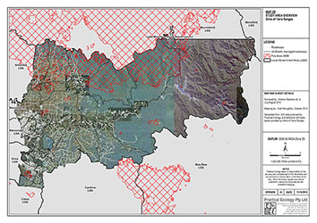 Following the 2009 Black Saturday fires in Victoria Practical Ecology was commissioned to undertake and assessment of fuel loads and post fire regeneration on road sides within the Nillumbik and Yarra Ranges Shire Councils. The main objective of this study was to undertake an assessment of the roadside vegetation in response to the recent fires and provide management recommendations to ensure the ongoing effective functioning of the utility and safety of road infrastructure, whilst protecting their unique amenity and conservation values.
This project involved a number of key GIS innovations including:
-
Custom designed databases and data collection forms for direct collection of GIS data in the field on mobile devices ensuring high efficiency and data quality
-
GIS analysis techniques used to generate statistics and make recommendations based on this data
-
Presentation of data in high quality maps
-
GIS data provided to clients on project completion in the required data formats