


 Weed Management Plan for Eden Gardens Estate, Wollert: 2015
Practical Ecology prepared a Weed Management Plan for Eden Gardens Estate in Wollert. The Plan was sought by the developer of the site in response to a Planning Permit Condition issues by Whittlesea City Council. The Plan provided a comprehensive list of weeds present on the property, outlined the developers weed control and management responsibilities, identified high priority weeds, and outlined suitable control methods and techniques for the various weeds identified on the property. A timetable of weed control works was also included, along with machinery hygiene protocols consistent with best management practice that were aimed at managing the spread of weeds as development progressively took place on site.
 Farm Management Plan for Private Property in Tooberac: 2015
This project was undertaken for a private landowner as part of a request for information from Mitchell Shire Council in relation to the establishment of a dwelling on a private property located within a Farming Zone. This Plan incorporated a review of existing conditions on the site and an overview of the proposed development of the site as its intended use for cattle and sheep grazing. As part of the Plan, various actions were discussed in order to manage livestock and other activities on the site while balancing the need to take areas of native vegetation and waterways into consideration. Various issues and proposed management actions were addressed, including fencing, livestock and pasture management, pest plant and animal management, erosion and sediment control, management of conservation zones, revegetation and farm water balance. A management regime was developed to guide works in relation to these topics over a period of five years.
 Ecological Assessment for Coliban Main Channel Renewals, Mt Alexander and Bendigo municipalities: 2015
Practical Ecology was commissioned by Coliban Water to prepare an Ecological Assessment for sites along the Coliban Main Channel that are associated with channel renewal works in the Mt Alexander and Greater Bendigo municipalities. The assessment included EVC identification and mapping, habitat hectare assessment, flora and fauna survey and weed mapping. Recommendations were provided to minimise impacts of the works on the identification ecological values.
 EPBC Act Referral for subdivision in Langwarrin, Victoria: 2014
During the process of preparing of a Flora and Fauna Assessment and Site Environmental Management Plan (SEMP) for a subdivision in Langwarrin, it was recognised that a number of species listed under the Environment Protection Biodiversity and Conservation (EPBC) Act 1999 could potentially use the site as habitat or be affected by the works proposed. Of particular concern was potential impacts on the Dwarf Galaxia Galaxiella pusilla that occurs in the adjacent Boggy Creek.
To ensure that a timely and efficient referral process ensued, Practical Ecology prepared a concise, yet comprehensive EPBC referral on which the assessment process could be based. It included details of the mitigation measure to be implemented as part of the development that aimed to avoid and minimise impacts on ecological values. The provision of such a detailed referral ensured that the project was not deemed to be a ‘controlled action’; the development was able to proceed provided that the measures comprehensively detailed in the referral, were undertaken during the course of the development.
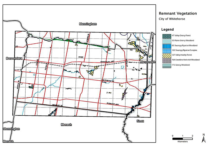 Urban Biodiversity Strategy for Whitehorse City Council, Victoria: 2013-14
Practical Ecology was commissioned to prepare a Biodiversity Strategy for Council Managed Open Space within the City of Whitehorse in 2013/14. Council owns or manages the largest area of public land within Whitehorse (approximately 10% of the municipal area), hence biodiversity actions within this land potentially provides the largest scope for biodiversity conservation, protection and enhancement within the municipality.
The Biodiversity Strategy initially provided background information on defining what Whitehorse biodiversity is, and what the Whitehorse biodiversity assets are. It also provided a statutory context, information on the Whitehorse landscape and its remaining biodiversity, and the current Whitehorse biodiversity management actions. The Biodiversity Strategy then proposed a series of Biodiversity Actions revolving around current biodiversity management actions that could be enhanced, new biodiversity actions (one-off commitments) and on-going biodiversity actions that would require on-going funding and commitment. The Strategy will be reviewed in ten years (2025), and monitoring, evaluation and reporting was built into each of the proposed Biodiversity Actions.
Practical Ecology prepared the draft working document, undertook three consultation workshops (with Council open space management workers, with internal Council departments and with external stakeholders such as members of Bushland Advisory Committees and Friends Groups), and prepared the final Strategy in conjunction with the Council Steering Committee.
 Peer review of documents submitted for proposed sub-division in St Helena, Victoria: 2013 -2014
Practical Ecology was commissioned by Banyule City Council to undertake an independent review of various documents submitted as part of a planning permit application to establish a residential development across several properties within the St Helena/Greensborough area. This included an in-depth review of the information prepared within the flora and fauna assessment and impact analysis that had been prepared by another ecological consultancy, as well as various other documents including a Bushfire Attack Level (BAL) assessment, landscape plan and drainage plan.
Through a desktop review of relevant documents and databases, along with a site assessment, Practical Ecology identified a plethora of issues with the documents originally submitted. This included those pertaining to the results of the flora and fauna surveys undertaken on site, as well as the classification of the Ecological Vegetation Class on the site and Habitat Zone boundaries. The Net Gain analysis was also proven to be fundamentally flawed. Following from changes to native vegetation regulations that came into effect in December 2013, Practical Ecology again reviewed the documents submitted to council after assisting with the preparation of a ‘Request for More Information’. This additional review found that while some of the issues had been addressed in the revised documents, other issues had not been and additional ones were present. The information prepared aimed to assist Council with their decision regarding a planning permit for the site and any conditions that may be attached to this permit.
 Flora and Fauna Assessment for Alphington Station, Victoria: 2013
Practical Ecology was commissioned by VicTrack to prepare a Flora and Fauna Assessment to inform the proposed redevelopment of Alphington Station. The site contains significant River Red Gums representative of Plains Grassy Woodland. Recommendations on how to minimise and avoid impacts associated with the proposed development and considerations to minimise impacts during construction where also provided.
.
.
.
 Flora and Fauna and Bushfire Assessment for Mount Helen NBN Tower, Victoria: 2013
Practical Ecology was commissioned to prepare a Flora and Fauna Assessment, Net Gain Analysis and Bushfire Risk Assessment for a proposed telecommunications tower for the National Broadband Network (NBN). Management and design recommendations were also provided to minimise ecological impacts and manage fire risk. Special consideration was required for the resident Koala population.
.
.
.
 EPBC Act Referral for Plenty River Trail (Stage 6 & part Stage 7), Victoria: 2013
Practical Ecology Pty Ltd was commissioned by Parks Victoria to prepare an EPBC referral as part of proposal to install a multi-purpose pedestrian/bicycle trail through the Plenty Gorge Parklands within the suburbs of South Morang and Mill Park, Victoria. The habitat the trail would travel through included the EPBC-listed ecological community, Grassy Eucalypt Woodland of the Victorian Volcanic Plain, potential habitat for the Golden Sun Moth and known locations of listed flora species such as Matted Flax-lily.
Detailed flora and fauna surveys were undertaken by Practical Ecology to detect EPBC-listed protected species and vegetation communities known to occur in the local area and to consider any potential impacts the construction of the trail alignment may have on matters of national significance under the Environmental Protection and Biodiversity Conservation Act 1999.
The EPBC referral that was prepared outlined the amendments to the trail design that were made with the assistance of Practical Ecology to ensure that impacts would be minimal. This included changes to the location of the trail alignment, between particular trees for example, to ensure that all Large Old Trees are avoided, along with avoiding and minimising losses of high quality vegetation; the addition of a section of an elevated boardwalk style trail which aimed to deter trail users going off the trail and forming additional paths though the high values of the study area; and proposed utilisation of sensitive construction techniques including hand excavation around trees where their Structural Root Zone was encroached.
 Pre-purchase ‘due diligence’ for warehouse developments, Victoria and Tasmania : 2011-2013
Between 2011 and 2013, Practical Ecology completed a number of ‘due diligence’ type assessments on sites across Victoria and Tasmania for a client intending to purchase these properties to develop commercial warehouses. These sites were located in Launceston and Kingston in Tasmania and Bacchus Marsh, Epping, Morwell, Mernda and Swan Hill in Victoria.
These assessments included a brief literature review of the study site and surrounding area to explore the findings of past report and documents. A search of relevant databases was also undertaken to determine the potential for any significant flora or fauna species known to occur within the local area to occur within the site or utilise it as habitat. The information gathered from the desktop review was augmented by that gathered as part of a site visit to determine the ecological values on the site and in some case, also determine potential issues pertaining to the threat of bushfire. A brief report was subsequently compiled for each site outlining the methods used to gather information and the results of the assessment. This was accompanied by mapping highlighting the values identified on site.
 Native Vegetation Precinct Plan for Maiden Gully, Victoria: 2012-2013
A flora and fauna assessment was undertaken on behalf of the City of Greater Bendigo to assist with development of a Maiden Gully Precinct Structure Plan (PSP), and thus, the preparation of a Native Vegetation Precinct Plan (NVPP). The purpose of the flora and fauna assessment was to provide information on the flora and fauna species, Ecological Vegetation Classes (EVCs), and fauna habitats occurring or predicted to occur within the assessment area.
The main objective of this study was to identify areas of vegetation identified as being of highest priority for retention and protection, and subsequently providing recommendations for the establishment of a new mixed use area that is largely residential, with remnant patches of native vegetation buffering and complementing the adjoining public and private forested areas. This included careful consideration of developing and further enhancing existing vegetation and fauna habitat corridors.
 Monitoring biodiversity gains due to weed control – Central Highlands Eden, Victoria: 2012-2013
Practical Ecology was commissioned by Department of Environment and Primary Industries to undertake monitoring of weed infestations within a defined area of Victoria’s Central Highlands; the Central Highlands Eden project area. The Central Highlands Eden (CHE) project is a long-term, landscape-scale weed management project currently underway within Victoria’s Central Highlands region. As part of the project, particular weed control works and their impacts on local biodiversity values, within nominated Asset Areas are being monitored.
The monitoring strategy is designed for long-term monitoring which will produce ongoing reporting that will feed into the adaptive management process of the CHE project. It involved the establishment of 64 monitoring plots where flora data and other site data were collected.
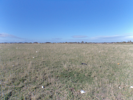
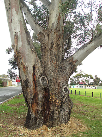
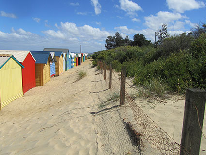
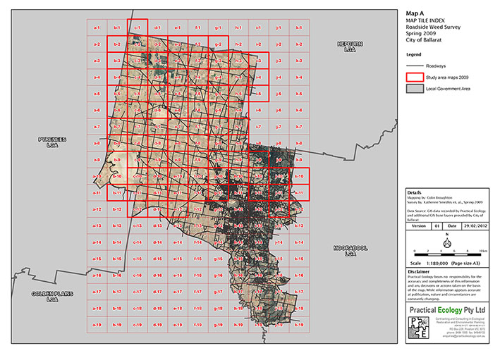 Rural Roadside Weed Mapping and Management Project for City of Ballarat, Victoria: 2009-2013
Practical Ecology undertook surveys of 500 km of roadside reserves within the City of Ballarat to identify the extent and type of weed infestations present. The rural areas were comprised of four sections, including Buninyong, Learmonth, Burrumbeet and the surrounding areas of these towns, and North-East Ballarat. The data was collected using hand-held GPS units and PDAs, with mapping presented at a 1:10,000 scale. More than 1,600 weed records were collated. From this data, Practical Ecology was able to define the weed management requirements and priorities for roadsides within the City of Ballarat. We were subsequently commissioned (in late 2013) to assist with preparing a weed management and rabbit control plan reflecting these results.
.
. Fauna Survey in foreshore and bushland reserves for Bayside City Council, Victoria: 2012
Practical Ecology was commissioned by Bayside City Council to provide management recommendations based on detailed fauna habitat surveys of fourteen foreshore and bushland reserves within the municipality of Bayside. These reserves provide a variety of habitat types, which supports a wide range of fauna, including some migratory shorebirds which occasionally feed or roost on the rocky promontories and on the sandy shoreline.
The study undertook detailed mapping of fauna habitat values across the entirety of each reserve, focusing on habitat features not captured by the Habitat Hectare method. These values included rock and litter cover, log habitat, tree hollows and major structural components (e.g. shrubs and groundstorey vegetation)
The study summarised results from the fauna habitat survey within these reserves in tabular and detailed map form. Management and monitoring recommendations were also provided to Council, in order to maintain and further enhance native fauna populations within these sites.
 Bushland Reserves and Cardinia Creek Habitat Value Assessments for Cardinia Shire Council, Victoria: 2011-12
Practical Ecology undertook two projects assessing Habitat Values and weeds threats for Cardinia Shire Council during 2011-12.
The initial project involved investigation of twelve reserves within the Cardinia Creek and Stoney Creek Catchments to map the extent, condition (Habitat Hectare assessment) and Ecological Vegetation Class of native vegetation within each reserve as well as undertaking supplementary weed mapping in five reserves. The project was also used to determine current available habitat for three priority fauna species (Powerful Owl Ninox strenua, Helmeted Honeyeater Lichenostomus melanops cassidix and Platypus Ornithorhynchus anatinus) and provide information on priority weed species that threaten biodiversity and their method of removal.
The second project involved Habitat Value Assessment and Weed Mapping focussing on six reserves and ten roadsides of high conservation significance within the Cardinia Shire Council. This involved vegetation quality assessments (i.e. Habitat hectare assessments), identification of habitat management zones, identification of key dominant weed species, prescriptions for treatment over 4 years and establishment of monitoring plots as appropriate.
The information generated by the project will be utilised by the Council to inform future weed management work as part of their project under the Urban Fringe Weed Management Initiative, a program designed to protect identified ecological values on public land in Melbourne’s outer suburbs from the threat of weeds.
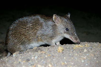
 Fauna Linkages and Crossing Structure Design for Frankston City Council, Victoria: 2011-2012
Practical Ecology Pty Ltd was commissioned by Frankston City Council to undertake a detailed in investigation of fauna linkages and wildlife crossing structures within Frankston and adjoining landscape. This study applied a quantitative method to the identification and prioritisation of fauna linkages both at the local and landscape scale to guide future investment and planning decisions by Council. The Southern Brown Bandicoot was selected within the project as a key surrogate species to guide the identification and prioritisation of linkages for fauna and subsequent specifications for habitat creation and maintenance.
The study also developed and applied a quantitative approach to the selection and prioritisation in time of locations requiring wildlife crossing structures to facilitate natural movements of fauna between important areas of habitat. In prioritising linkages the study assessed not only the conservation significance of the linkage and connectivity benefit to faunal populations but also the feasibility of implementing each linkages considering numerous factors such as tenure, road barriers, parcel size etc. The project involved extensive liaison with stakeholders, managers, researchers, and community groups/members. Complex high level GIS analysis was applied to the questions posed by the study using novel approaches developed by our company. The project further built on many years of past experience including a series of projects involving the conservation of threatened species and provision of connectivity for fauna populations. Detailed management recommendations and specifications were provided for two high urgency wildlife corridors and for wildlife crossing structure options to mitigate barriers to faunal movement.
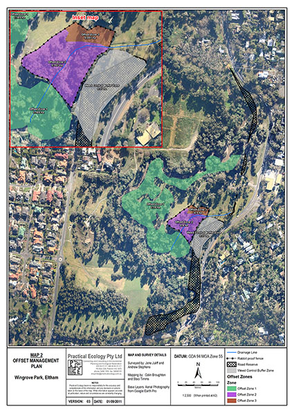 Offset Management Plan for Wingrove Park in Eltham, Victoria: 2011 – 2012
This project was undertake on behalf of VicRoads. Practical Ecology prepared a management plan for a section of Wingrove Park in Eltham in order for it to form part the native vegetation offset required for the removal of vegetation in association with the re-development of a nearby bridge in Eltham. This project involved a comprehensive flora survey, vegetation mapping, vegetation quality assessments and identification of management issues within the site. This was followed by a detailed and comprehensive offset management plan that formed the basis of tender specifications for prospective contractors tendering for the proposed ecological restoration works.
.
.
.
.
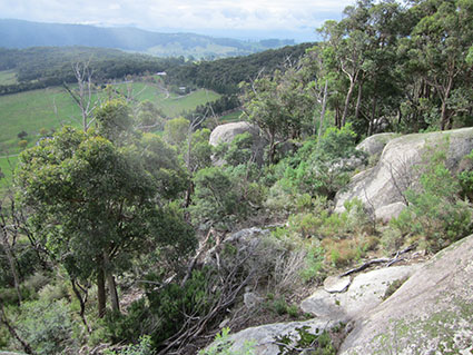
 Flora and Vegetation Condition Assessments in the Tarkine, north-west Tasmania: 2011
Practical Ecology Pty Ltd was commissioned by Cradle Coast Authority to provide a flora and vegetation condition assessment of selected sites throughout north-west Tasmania. The main purpose of this study was to better understand the floristic and vegetation values at ten selected sites within the Tarkine.
Vegetation in the study area was assessed for type, condition and extent. A number of TASVEG vegetation communities were present at the ten sites, with five dominant types present: Buttongrass Moorland, Wet eucalypt Forest, Rainforest, Montane Grassland and Coastal Heathlands/Grasslands. Most sites were highly intact with disturbance and threatening processes mostly related to previous logging operations, construction of roads, inappropriate fire regimes and cattle grazing.
During the surveys, 264 plant species recorded of which 252 were indigenous and twelve were introduced or weed species. A number of rare and threatened flora species were recorded.
 Property Management Plan for private property in Merricks, Victoria: 2011.
Practical Ecology Pty Ltd prepared a Property Management Plan for a site in Thompsons Lane, Merricks. This plan was triggered by Mornington Peninsula Shires response to a planning application for development at the site. The scope of works proposed by Practical Ecology and then completed included:
• background information and associated mapping of existing site conditions
• documentation of significant management issues such as erosion, salinity and weed infestation
• an assessment of any potential impacts on existing site conditions, and the areas immediately surrounding it such as increased erosion or weed infestation
• details of recommended land management actions to be implemented to address the impacts of the proposed development and other key land management issues identified at the site
• a 5 year schedule of works incorporating proposed mitigation measures and all other high priority land management actions.
 Roadside Management Plan for Nillumbik Shire Council, Victoria: 2010-12
Practical Ecology was commissioned by Nillumbik Shire to prepare a Roadside Management Plan. This involved an assessment of roadsides to:
• identify and map roadside conservation significance using a modified version of the Victorian Roadside Advisory Committee Assessment method
• identifying presence and potential habitat for any rare of threatened flora and fauna.
• identify and map roadside weeds in accordance with existing council mapping and the National Core Attributes for Weed Mapping.
The results of the assessment were incorporated into a new Roadside Management Plan for the shire which was adopted by council in 2012. The plan included two main parts: the first part contained an identification of values and management issues with broad policy objective. The second part provided operational guidelines for construction and maintenance works on roadsides. To assist with the implementation of the new Plan, Community Roadside Management Guidelines (CRSMG) were subsequently developed to provide a concise overview of the RSMP for use by community members and service providers who undertake activities on roadsides.
This project involved collection of a large amount of data about the values and management issues of roadsides into a GIS database which involved:
• Custom designed databases and data collection forms for direct collection of GIS data in the field on mobile devices ensuring high efficiency and data quality
• GIS analysis techniques used to generate statistics and make recommendations based on this data.
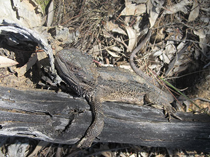
 Southern Brown Bandicoot Sub-regional Surveys and Strategies for DSE, Victoria: 2010-11
Practical Ecology developed a Southern Brown Bandicoot Sub-regional survey for Victoria’s Department of Sustainability and Environment in 2010. Targeted survey work was undertaken to provide the necessary information to develop the strategy, which outlined the conservation goals and priorities for the Southern Brown Bandicoot in Melbourne’s south-eastern growth corridor, including the development and placement of corridors to link Southern Brown Bandicoot populations and recommendations on how to best manage and improve current Southern Brown Bandicoot habitat.
The surveys undertaken as part of this project utilised various techniques including infra-red motion sensor cameras, active searching for diggings, and identification of nests. Thirty sites were monitored for the presence of Southern Brown Bandicoots over a four week period. Camera trap plots were set for a 14 day period with SD cards downloaded and batteries replaced after seven days. Southern Brown Bandicoots were detected at four new locations with camera traps and potentially 16 locations within the sub-region through identification of diggings.
The project produced a technical report and recommendations to guide the draft Southern Brown Bandicoot Sub-regional Species Strategy (2011) by the Department of Sustainability and Environment. The information and recommendations provide as part of the report prepared was used as part of planning processes for the new south east growth area of Melbourne, as required by the Melbourne Strategic Assessment. The report was prepared for submission to the Commonwealth for approval as required by this Strategic Assessment Program.
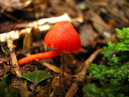 Tarkine Fungi Survey: Corinna, Philosopher Falls and McGowan’s Falls, north-west Tasmania: 2010
Practical Ecology Pty Ltd was commissioned by Cradle Coast Authority in May 2010 to undertake a fungi survey of three sites in the Tarkine. The survey focussed on species with a Gondwanan link. The cool temperate rainforest of the Tarkine is the largest contiguous area of Myrtle Beech Nothofagus cunninghamii rainforest remaining in Australia. Many fungal species can only persist in climatic conditions favourable to Myrtle Beech or are obligate associates.
A total of 221 species of fungi were mapped during the survey. Several species were of the Gondwanan distribution some of which included Strawberry Bracket Fungus Aurantioporus pulcherrimus, Beech Orange Cytarria gunnii and Austral Dripping Bonnet Mycena austrororida. It was recommended that further surveys be carried out to enhance the current fungi inventory.
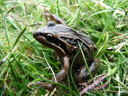 Fauna Surveys at Specified Sites on the Yarra River for City of Boroondara, Victoria: 2010
Practical Ecology was commissioned by the City of Boroondara to undertake fauna surveys at specific sites on the Yarra River including Freeway Golf Course, Willsmere-Chandler Park and Yarra Flats Reserve.
The main purpose of this study was to increase the knowledge of indigenous fauna present within the City of Boroondara. Methods utilised included spotlighting, active searching, trapping and vocalisation identification. A total of 47 species of native fauna were recorded within the study sites. This includes species of amphibians, reptiles, birds and mammals.
The study made an important contribution to the larger existing knowledge of fauna within the City of Boroondara. The significance of the area has been detailed in previous studies. With an ever increasing level of urbanisation, managing areas of habitat is vitally important for biodiversity conservation. Recommendations included ongoing monitoring of fauna, weed control, and continuation of revegetation throughout and the enhancement of Koonung Creek as improved habitat and a ‘stepping stone’ corridor for wetland species.